February Cold Spell ’18 Wrapup….And From Cold To Chilly?
With the arrival of west wind and temps in the 40s today Saturday, our late February cold snap in the Columbia Gorge is officially over! And what an event it was…roughly six days from beginning to end, and with multiple snowstorms, it was the most impressive late February cold spell in our region since 1993.
TEMPS
Here are the temperature stats for the five “core” days of the cold event, February 19-23 (Mon-Fri):
DATE HI LO MEAN DEPART
2/19/18 35 22 28.5 -12.0
2/20/18 33 20 26.5 -14.2
2/21/18 33 16 24.5 -16.4
2/22/18 35 20 27.5 -13.6
2/23/18 37 13 25.0 -16.3
It’s very tough to get high temps below 30-32 degrees in the 2nd half of February; the sun angle is just too strong. That said, highs in the 20s DID happen toward the end of the February 1993 cold event. That one was MUCH colder and longer-lived than 2018; it lasted fully two weeks and was aided by deep and widespread snow cover across most of Eastern Oregon & Washington.
The high of 33 on the 20th set a new record cold high for the date, and the low of 13 on the 23rd obliterated the old record low of 20 degrees. Interestingly, that daily record low was set during the warmest February ever (2015).
SNOW
We saw snowfall in The Dalles several times during this cold event, as chilly low pressure systems kept diving down the coastline from British Columbia:
1. A trace of snow early Sunday morning, as the first maritime subarctic airmass was arriving.
2. About 2.0″ late Sun night / early Mon morning, with the arrival of the arctic front.
3. Roughly 3.3″ on Tuesday night.
4. About half an inch on Thursday morning.
5. And finally, 2.5″ early Saturday morning.
Add it all up, and the total comes to at least 8″ at river level, and probably somewhat more in the hills south of town. However we never came close to having 8″ of snow on the ground. That’s also due to the late February sun angle, which melts/evaporates snow very quickly even if air temps stay near or below freezing. This same series of snow events would have produced a much deeper and more continuous blanket of white, had they occurred in December or January !
==========
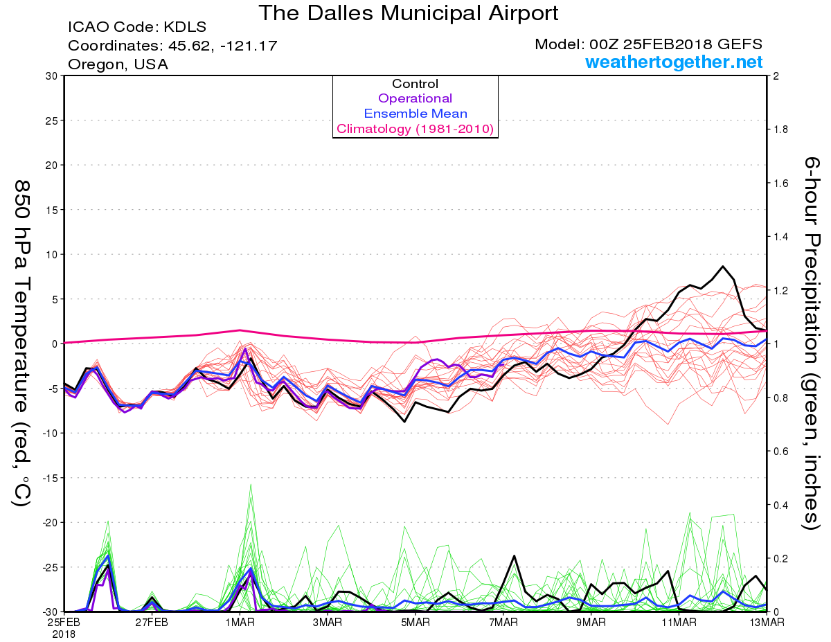
Now that the cold event is over, what do we have coming up? Unfortunately, I don’t see any genuine spring-like weather anywhere in sight. We’re merely shifting from an unusual late-season cold pattern, to a more typical chilly late winter pattern. That means lots of snow for the Cascades and higher parts of Eastern Oregon, and lots of cold rain for the valleys and Gorge.
The 00z GFS ensemble chart says it all for The Dalles: still colder than normal, but no more arctic cold:

In the middle of winter it’s not too tough to get snow with 850mb temps of -5 to -7, provided there is some sort of low-level cool air in the Gorge and points east, that doesn’t immediately get scoured out by west wind. But the rules change as we get toward early March: inversion season is done with now, and it’s much easier to get strong west wind coming through the Gorge. Also in this pattern, the Cascades tend to eat up all the moisture while The Dalles suffers from a strong rainshadow effect.
It’s still possible that Hood River or White Salmon (or maybe even The Dalles) sees a brief dusting of snow in the night or morning under a cold band of showers. But most of the snow activity in the Gorge will probably be confined to places above 1000′ elevation, and snow is especially likely once you get up to 1500′ or higher.
So even though the big lowland snow and ice is probably done for the season, I’m not pulling out the fork today. With all the chilly North Pacific storms and heavy snow piling up in the Cascades and High Desert these next couple weeks, it’s safe to say that Winter 2017-2018 isn’t quite over yet!