Final Snow/Cold Update
We’re now less than 24 hours away from a somewhat historic late-season cold snap in the Pacific Northwest and Columbia River Gorge. And it’s coming on the heels of one of the mildest midwinter periods we’ve ever experienced, which makes for more of a shock.
Summary
1. It’s still not looking favorable for major snow accumulations in the Willamette Valley or Gorge lowlands. The fundamental problem is that there’s not enough moisture as the really cold air arrives.
2. However, Sunday’s arctic low-pressure system WILL bring snow levels extremely low beginning tomorrow morning – at least down to 1,000 feet and possibly lower. I bet the western lowlands at least see plenty of flakes in the air tomorrow!
3. Monday night/Tuesday morning will likely be the coldest night of the entire winter season. Temps down into the low 20s even in downtown Portland, and likely low-mid teens in The Dalles. (This is assuming that we don’t get much widespread snow cover from Sunday’s storm.)
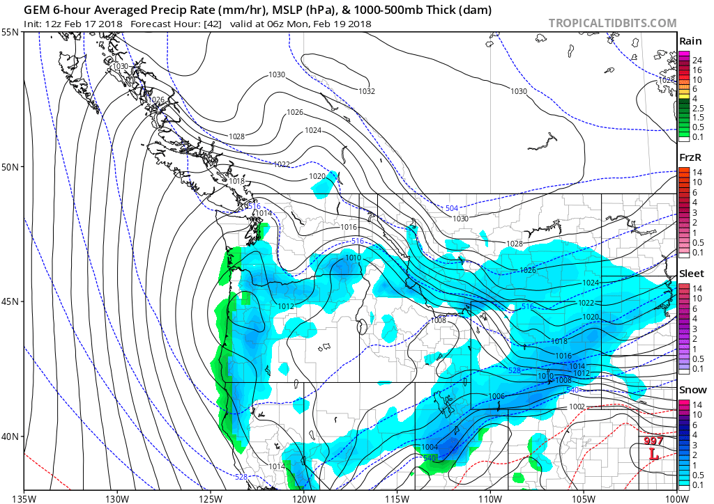
I’m not going to blabber on at length, so here are the maps. First, the 12z GFS precip map for 4pm tomorrow Sunday afternoon:

Just a little bit too warm for snow in the Willamette Valley. By 10pm colder air is arriving but showers are dying out. Not the best for snow.
The GEM model looks slightly better for a quick inch or half-inch in the western lowlands, due to precip lingering a bit further into the evening. More moisture at 10pm = more snow.

Then we have the WRF-GFS accumulation maps for the critical period 4am Sunday – 4am Monday:

Same basic idea: a light dusting is possible in Portland and the valley. Bigger accumulations in the mountains and Coast Range.
What about the central/eastern Gorge? It generally doesn’t look good for lowland snow, both due to marginal Sunday temps and the “rainshadow effect” from Hood River eastward. But we will have to watch carefully on Sunday evening as the arctic air arrives from the north/northeast. Arctic fronts CAN produce a quick inch or two of snow when they pass through The Dalles, but not always. It’s really tough to know ahead of time, what’s going to happen.
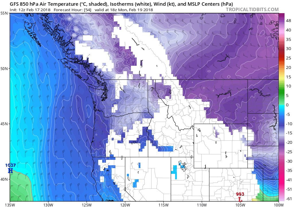
The next question is what happens Monday & Tuesday night, when the cold air has passed over. Here’s 10am Monday morning.

The boundary between the dark blue and pale “whitish blue” just south of Portland? That’s an 850mb temp of -11.5 degrees Celsius. So PDX will be around -12 and DLS close to -14, which is actually very similar to the February 2011 cold snap.
That time, we didn’t have any snow cover in the lowlands, but as I recall the highest hills around town did have a dusting. Temps got all the way down to 9F on the morning of the 26th! That’s by far the latest single-digit occurrence in airport history. If we get a perfectly calm and clear night Monday night, we might be down pretty close to that, let’s say in the 10 to 12 F range. (Of course, if you assume widespread 2-4″ snow cover east of the Cascades, it changes the ball game significantly. But I don’t think that scenario is going to happen this time.)
For now I’m just going to assume some number around 15 for Tuesday morning, and a few degrees warmer Wednesday morning. The daily record low for Tuesday the 20th is 16 degrees F, set in 2006. A modified arctic airmass had come down a couple days earlier and was now beginning to moderate somewhat. The record low for the 21st is also 16, but it comes from 1993. That was in the aftermath of a major late-season snowstorm on the 19th, which brought tons of snow to Portland, The Dalles and the Columbia Basin.
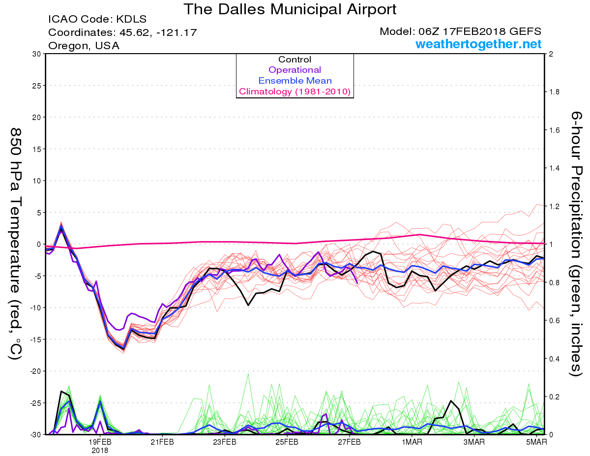
After next Wednesday, things appear to moderate for good. We’re going into a more typical late winter chilly ‘La Niña pattern’, with tons of snow above 1,500 feet, cold valley rain, and occasional teases of snow pretty close to sea level. It would be fun to see an arctic airmass on or after March 1 one of these years, but as of now there’s no hint of a signal in the ensembles:

In any case, Winter 2017-18 may have gotten off to a VERY slow start this year, but now it appears poised to finish strong. Cheers!