Another Rough Summer For The West
(sorry, I don’t have a good fresh photo of the red smoky sun!)
As you can probably tell, it’s been a very tough summer for much of the Western U.S., and even parts of Canada. So far there have been five big wildfires within local range of The Dalles, burning well over 100,000 acres. Multiple conflagrations of historic magnitude, have blazed throughout Northern California. Now we are seeing haze from fires in British Columbia and Alberta, brought into Washington & Oregon by north winds aloft.
This is unsurprising, after a record-warm late spring and now an unusually hot and dry summer across the region. Since about the 11th of July, we’ve seen 3 major heatwaves in a 4-week period. Worst of all was the prolonged hot stretch in late July, when we stayed above 95 for an 11-day run, including 7 days 100+.
Furthermore, there have been no significant periods of below-average temps in between the heat waves; just a brief cooldown for a couple days before the next hot ridge moves in. We can’t seem to get more than three days at a time, cooler than the mid-90s.
Now we’re into mid-August and there’s a 4th hot airmass beginning to build overhead. This one feels a little different because we’re starting it off with somewhat cooler nights – many places in the lower Columbia Basin were in the low/mid 50s this morning. The longer nighttime hours are definitely becoming obvious now, but we also got some Canadian air influence east of the Cascades both Sunday and yesterday Monday. That can lead to cool-ish nights even as you go into a hot midsummer pattern.
Another factor right now is the dense smoke. This is the kind of day where we could lose 5-7 degrees of heat due to the sun being obscured. I’m expecting a high temp of 96 to 99. If it was clear outside, today could easily hit 100 degrees or hotter. The atmosphere heats up more by tomorrow and there’s light westerly flow, that sounds good for more heat and less haze. Then we cool down a little again for about 3 days, to the low-mid 90s, before the heat returns by next Sunday.
So far this year, we have had 27 days at 95F or hotter, at the airport in Dallesport. The normal climatology for 1981-2010 is about 21 days per year. Typically we see about 8 days each in July and August, and 2 each in June & September. That helps explain the popular notion that July and August are the only two “real” summer months in our climate. Prolonged stretches above 95 are quite uncommon in June and September, even though they do occasionally happen.
Interestingly, we’ve never managed to double the normal number of 95s. The record number of hot days was 35, in 1998. Compare that to our 100-degree climatology, where the all-time record (21 days in 1996) was double-and-a-half the climo norms of 8-9 days per year.
As of right now, we would need another 9 days 95+, including today, to set a new record for heat days at DLS. The forecast for the next 10 days suggests we will at least come close to tying the record this year. We would need another six days above 100 to set a new record in that camp. Could we pull that one off too, as the late August sun continues to weaken?
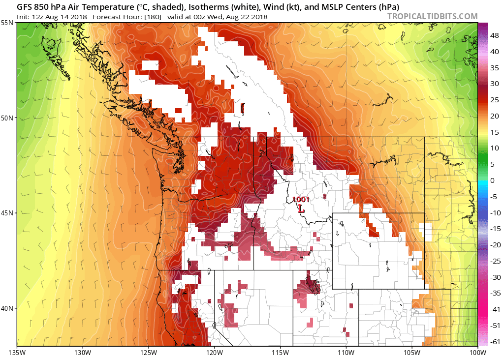
Generally speaking, after the 19th-20th of August it gets a little tougher to hit 100 in The Dalles, though it’s still possible into the 2nd week of September. Reaching 105 degrees is much harder to do, though. Most of our daily records after 8/20 are in the 100-104 range, as opposed to the 105-110s common in midsummer. You need a very hot airmass of +25C or more, and not much interference from smoke or haze, to pull off extreme heat toward the end of the season. Last year we were slated for a historic 5-6 day stretch of 100-105 degree temps in early September….but too much smoke from regional wildfires (including Eagle Creek in the Gorge) punched a big hole in our heatwave.
Nonetheless, the general signal is for more hot weather the first half of next week at least. Here’s the 12z GFS map for next Tuesday afternoon, just 7 1/2 days out:

In any case, Summer 2018’s fate is now sealed as an especially hot and smoky one. We may yet not set records for 95- and 100-degree days, but we will at least come pretty close. That means we will have 4 out of the past 5 summers as unusually hot ones, at least compared to the historical record.
Uh-oh…I smell a big discussion about regional climate change coming up in a blog post next month. Stay tuned!
One thought on “Another Rough Summer For The West”
My brother, who lives in Seattle, described it as like living in the Twilight Zone.