Good News! Cooler Weather Lies Ahead…

The last several days in The Dalles, I’ve noticed the feeling that we’ve moved past the “peak” of our summer season. We’ve had a few nights with low temps in the 50s now. That always seems to start at some point in either the middle or late part of August. The heat hasn’t been too bad for the past week, but that may only have been because of thick smoke. Temps last week were slated to touch the low 100s again, but 97 is the best (worst) we could do through all that haze.
We have about 3-4 more days early next week where there will be some combination of smoke and hot temps. Then…it appears a big change is finally going to come our way.
I’m a bit timid to get excited about this trend, mainly because we were supposed to get a cool spell back in early August – a cool spell that mysteriously vanished from the forecast and was replaced by a heat wave. But this latest trend has been on the model maps for several days now, and the cool signal isn’t weakening or getting pushed back. So I’m fairly confident it will be for real.
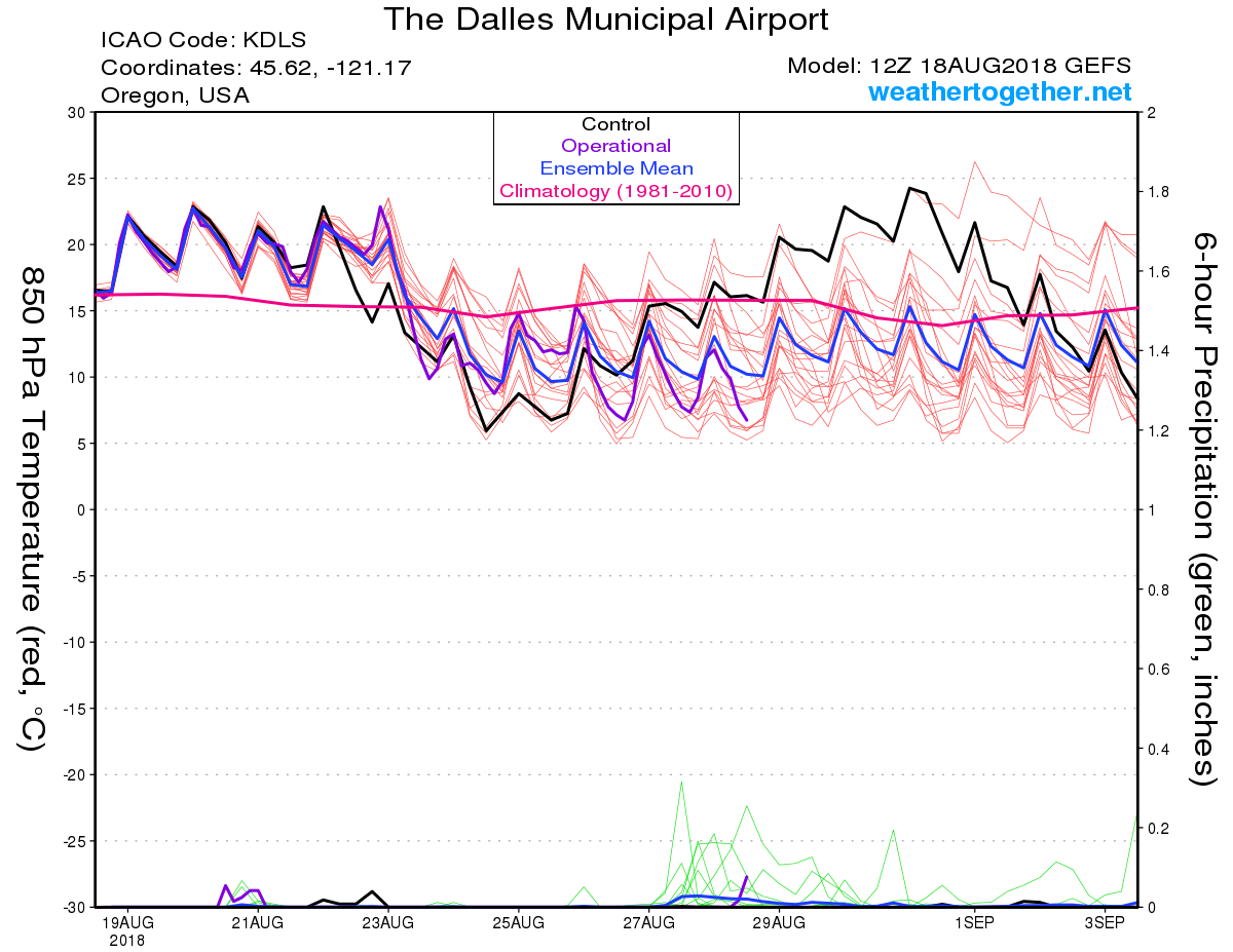
The 12z GFS spaghetti chart for The Dalles, shows a sudden dip in our daytime (00z) airmass temps beginning Wednesday:

We will see the afternoon 850 temps drop from +22-23, to roughly +12-14, a change of nearly 10 degrees Celsius. That would cause us to go from high temps 95-100 Monday-Tuesday (depending on smoke conditions), to more like 80 degrees by Friday. Maybe even some upper 70s if enough cool air penetrates the Gorge. And both the ensemble charts & long-range maps suggest that the crisp, pre-fall pattern is going to stick around the area for quite a while. (Again, the extended forecast is always subject to change!)
Some members of the ensemble are even trying to bring rain into the picture around August 27-28th, but that’s still pretty far off. But that would be a major welcome development, after all this drought and wildfire madness.
In short, we just might get one or two more days at 100 degrees next week, but then we’re probably done with extreme heat for the remainder of the season…UNLESS there is a massive hot ridge that develops in early September. Late-season heatwaves have happened a few times in the past couple decades: 1998, 2011, and arguably 2017 come to mind (though last year’s hot September ridge was undermined by dense smoke). We could still rack up quite a few days in the 95-103 range, this way.
Otherwise, we will probably finish the summer with 16 or 17 days at 100+. That’s not a record but it’s still way above historical norms. We will have at least 31-32 days 95+, without accounting for the possibility of a few more days in September.
Even if it doesn’t have quite as long and hot of a finish as I feared, the 2018 summer season is still going to go down as a nasty one. I think the warm, dry 2nd half of spring helped set us up for extra trouble this year. Basically the Pacific Northwest has been having ‘Mediterranean-type’ weather this year, almost ever since the end of April.
Maybe the upcoming cool pattern sticks around long-term. Or maybe we rebound into a strong “Indian Summer” pattern for September and October. Time will tell.
Enjoy the cool-down later next week!