September Sunshine
The calendar has turned to September, and with it comes the end of summer – as least as weather geeks define it. Meteorological summer is defined as the entirety of June, July, and August in the northern hemisphere. This is done mainly for calendar convenience. If you go by daily average temperatures, then summer in the Pacific Northwest and Columbia Gorge, runs roughly from June 15 through September 15. Other parts of the country see summer “peak” a week or two earlier than we do, so the June-August definition works out pretty well.
Nonetheless, summer 2018 is dying if it isn’t already over. Our nighttime temps are already dropping into the low 50s in The Dalles. And while it’s still possible to have a few days 95-100 degrees in the first half of September, that isn’t happening this year. Even if we did have a “big September heatwave” on tap, the longer nights all but guarantee that late evening through early morning will be comfortably cool. Unless there is a balmy west wind to keep us warm, it’s very tough to stay above 60 degrees all night in September.
Weaker sun angle also makes it tough to hit 100 in The Dalles in September, though it does occasionally happen.
How did August 2018 turn out? At DLS airport, it was 2.2 degrees warmer than normal. About what you’d expect from one major heatwave combined with a cool spell late in the month. We never got any 100-degree days after that hot stretch in early August; the smoke held things down quite a bit midmonth. We sure could have had another heatwave in there, had the cards come down slightly different.
The summer temperature is 74.39 degrees F. That is about 2.8 degrees above the 1981-2010 average. I’m pretty sure that’s the 5th hottest summer on record at the airport, after 1958, 1967, 1977 and 2015. We definitely had some hot summers in the 1990s, including a couple very warm Septembers. But of course, that doesn’t count for summer climate records!
And…of course, there hasn’t been ANY rain in the eastern Gorge since the middle of June. And nothing more than light sprinkles, even on the west side of the mountains. Normally a bone-dry summer by itself, isn’t enough to push into serious drought conditions – simply because summers are pretty dry to begin with.
But this year our dry season began in April rather than June. The entire 2nd half of April, and May, were all just as dry as July-August normally are. Combine that with the historically warm temperatures in May, and it’s no wonder that the native woods in the Gorge look so stressed-out. Basically the Pacific Northwest has had “California weather” ever since late April, and it’s definitely taking a toll. Much of the state of Oregon is now in Severe Drought status.
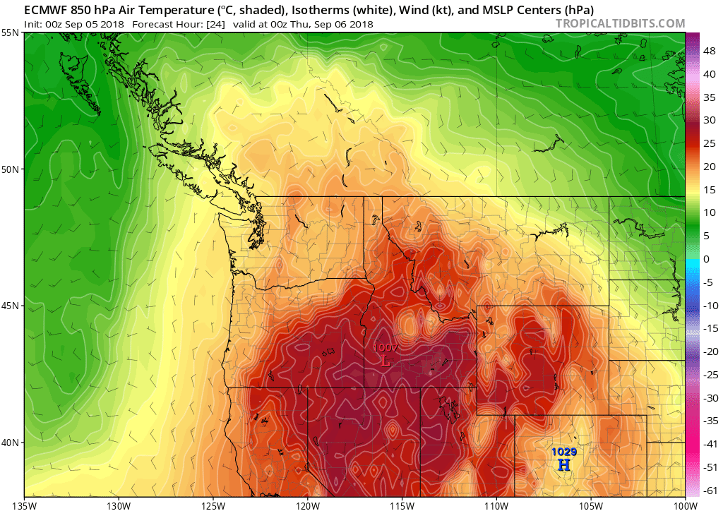
We have two more warmish-hot days, today and tomorrow Thursday. But then it should turn much cooler again. The 00z ECMWF maps, first for this afternoon:

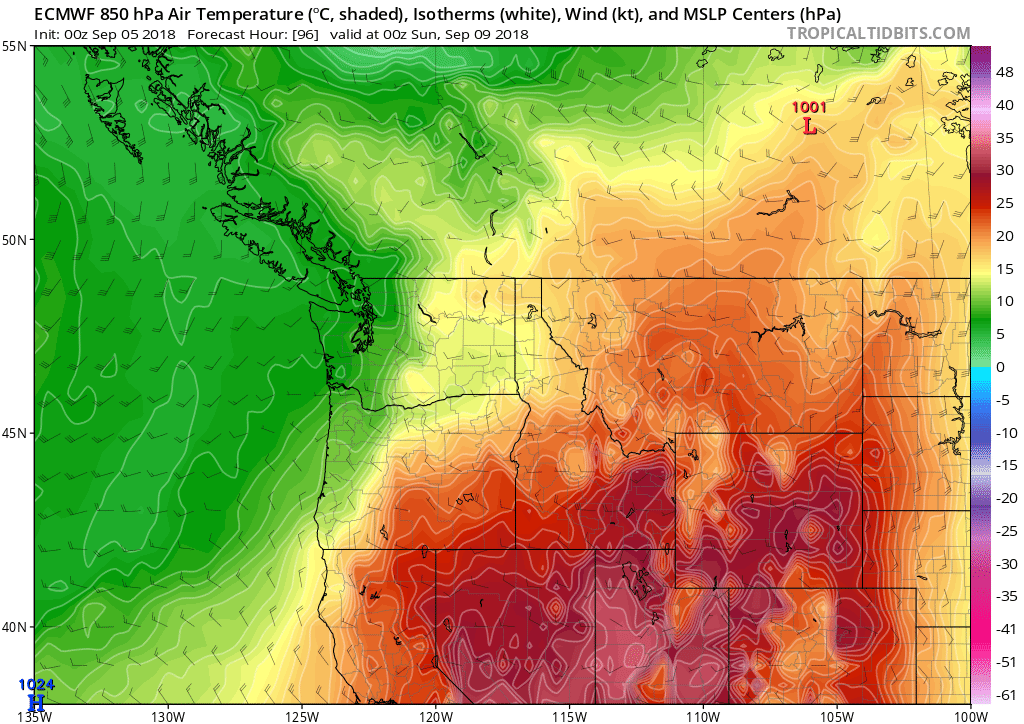
….And then for Saturday afternoon:

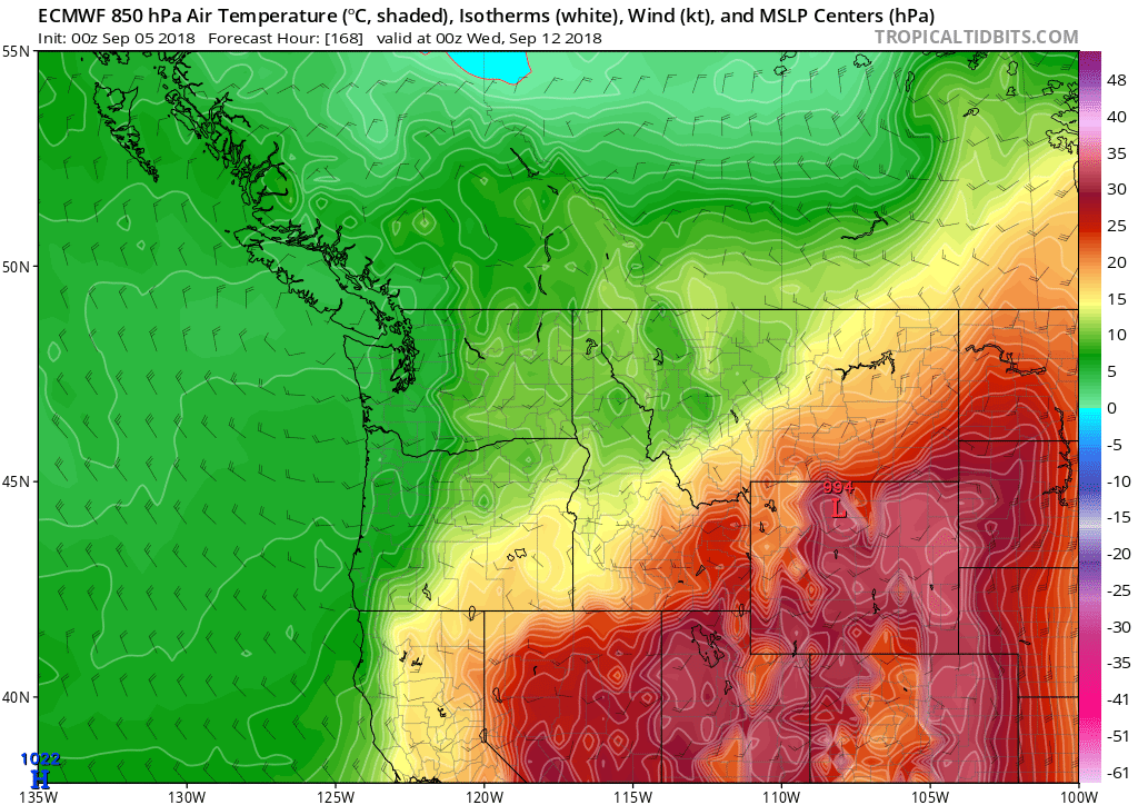
…And finally, next Tuesday afternoon:

The basic idea is for an extended period of cool and unsettled weather to kick in beginning late Friday, and continue through much of next week.
My guess is that real summer weather will probably be over after these next two days. The long-range maps show a cool and troughy pattern over the Northwestern U.S. through the 15th of September at least. Of course, it’s always still possible we could get a really strong “Indian Summer” pattern to set up in the 2nd half of the month. In 1994, that led to a 12-day stretch of low to mid 90s, at a time of year when normal high temps are only in the mid/upper 70s!
But for some reason, I have doubts about it happening this year. There just seem to be too many early fall airmasses drifting around the North Pacific, and western North America already. Oh well, we will just have to see. Most years in the fall we DO get at least one or two nice stretches of dry and clear weather, even if the temperatures aren’t extremely warm. Cool-and-dry seems to be a popular pattern in the fall, anyways…