After Thanksgiving: Big Changes Ahead
I hope you all had a very happy Thanksgiving this year! I was fortunate enough to be able to spend the evening with a group of dear friends from White Salmon. I’ve been going to potlucks with this “circle” for several years now, and plan to keep close ties with them in the future. We had a wonderful time telling stories and discussing our life plans.
Which brings me to an announcement: I am moving to East Portland, very near Gresham, in the first week of December. It’s been a fun eight years following the weather patterns in The Dalles, and I’ve learned a lot about the various nuances of our local weather and climate, in that time. But time marches on and so do my life plans…In any case, I plan to continue to emphasize the Columbia Gorge in this weather blog, since I will still be living quite close to it. But now I’ll be able to give a perspective on what the WEST end is like!
Anyway, on to weather…
The first 20 days of November, were extremely dry across most of the Pacific Northwest. The Dalles only received 0.04″ of rainfall during this time, when it normally averages about 1.34″ for the first two-thirds of the month. The first few days of November had enough warm southwesterly flow, that we stayed unusually mild. But since then, the dry, stable pattern has allowed for clear skies – and in November that means cold nights and/or inversions as the landmass rapidly loses heat. We actually had two separate ‘Fake Cold’ episodes this month – one on the 12th/13th and again on the 20th-22nd, where temps at DLS stayed in the 30s all day long! That’s pretty chilly for this time of year, even though we’ve been much colder during some of the early arctic blasts of the past (1955, 1985, 2014, etc.)
Due to the warm beginning of the month, temps for the first 3 weeks of November were actually very close to normal. But the last two weeks HAVE been quite cold for us, especially at night. Basically, for the eastern Columbia Gorge, I think we can say that “winter” began in the 2nd week of November this year.
This short-term drought has been no good for mountain snow pack, nor for the terrible wildfire season in California. Thankfully the rains finally returned on Wednesday and for yesterday’s holiday. And it appears that we have a far more active storm pattern ahead of us.
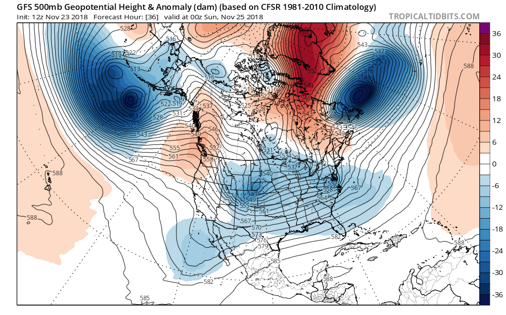
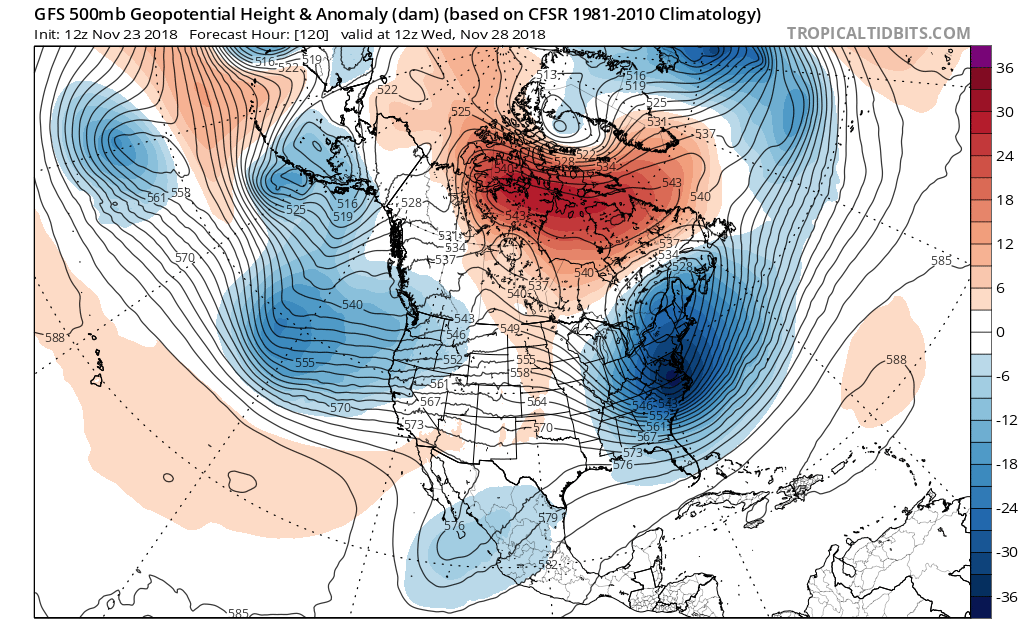
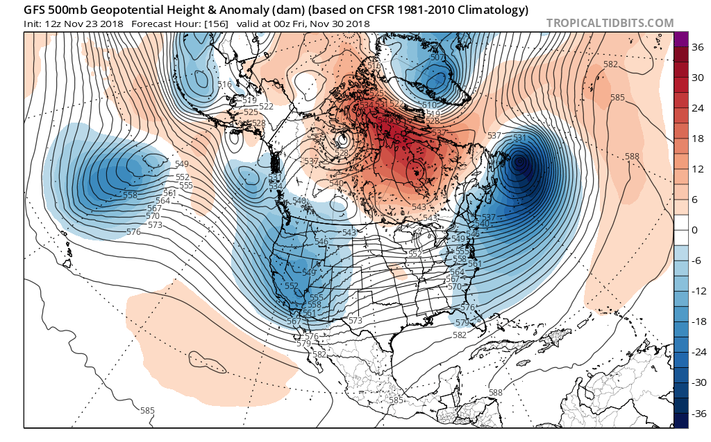
Instead of the typical maps showing precip, surface pressure and 850mb temps…I’m going to use the 500mb anomalies to illustrate what lies ahead. These maps measure the altitude at which the barometric pressure equals 500 millibars, and compares that number to the “normal” climatology for a given location at a given time of year. Hot airmasses usually have higher 500mb elevations, while cold unstable airmasses have the lowest “heights.”
The first map, showing conditions across North America tomorrow Saturday at 4pm Pacific:

There’s actually a very weak ‘ridge’ showing up along the coast of the Pacific Northwest and Western Canada. This signifies a shift toward somewhat drier conditions for the next couple days. Now on to early Wednesday morning:

There’s quite a lot of energy coming in off the Pacific, but the main brunt of it seems to be veering south. That’s actually very common in El Niño seasons. Instead of having a weak jet stream in the subtropics and a stronger one in the upper midlatitudes, one extremely strong jet can develop in the lower midlatitudes. And sure enough, next week’s storm track appears headed toward California:

A few strong storms in California can move them from catastrophic fires to catastrophic flooding and mudslides, in a matter of one week or less. By the way, a “split flow” pattern like this doesn’t necessarily mean dry weather for the PNW, at least not for Oregon. Quite often some of the rain makes it up here, even if the heaviest action is further south.
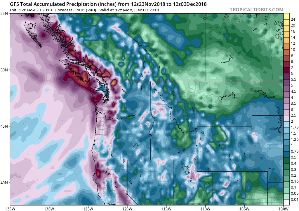
The GFS is clearly showing ample rainfall for the Northwest, even a fair amount east of the Cascade shadow. One other thing is strikingly clear: none of the recent model runs show any sign of arctic air in the PNW, any time in the next 10-12 days.

So my move at the beginning of December should be safe to go, though quite likely wet. Meanwhile, weather nerds will have to be patient, and maybe we see some kind of cold pattern later in the month. Who knows…?
One thought on “After Thanksgiving: Big Changes Ahead”
I was excited to find your blog a month ago. Please keep it up.